International Date Line Worksheets
About Our International Date Line Worksheets
The International Date Line might sound like something out of a science fiction movie, but it’s actually a very important part of how the world keeps track of time. This imaginary line runs through the Pacific Ocean and helps determine when one calendar day ends and another begins. These worksheets help students understand why the International Date Line exists, how it works, and what happens when people travel across it. Along the way, they’ll discover that keeping time on a global scale is more complicated than simply looking at a clock.
This collection explores the International Date Line from several different angles, including its history, location, connection to time zones, relationship to the Prime Meridian, and its effects on travel. Students will examine maps, solve real-world travel scenarios, build vocabulary, answer critical-thinking questions, and learn how crossing the line can result in gaining or losing a day. Through these activities, learners strengthen both their geography skills and their understanding of global timekeeping systems. The worksheets make a challenging topic much easier to visualize and understand.
One of the most fascinating things about the International Date Line is that it shows how people have worked together to organize a world that never stops moving. Whether someone is flying across the Pacific Ocean, coordinating international business, or simply checking the date in another country, the International Date Line plays a role. These worksheets encourage students to think globally while helping them understand one of the most unique concepts in geography. It’s a great example of how geography affects everyday life.
About Each Worksheet
International Date Line
This worksheet introduces students to the International Date Line and explains why it was created. They learn where it is located, how it relates to longitude, and what happens when someone crosses it. It’s a great foundation for understanding global timekeeping.
Global Timekeeping
Students answer questions that challenge them to think about how the International Date Line works alongside world time zones. The activity encourages them to connect geography with real-world travel and scheduling. It’s an excellent review of key concepts.
Reasons For the IDL
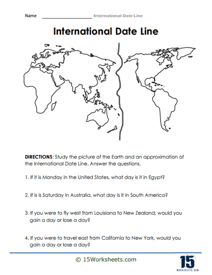
This worksheet explores why the International Date Line follows its unusual path across the Pacific Ocean. Students also get to practice locating it on a map and solving a travel scenario. It helps turn an abstract idea into something practical.
Implications for Travelers
Students examine what happens when travelers cross the International Date Line in different directions. The worksheet includes mapping activities and travel examples that make the concept easier to understand. It’s especially helpful for visual learners.
Across the World
This activity uses real-world examples to show how the International Date Line affects dates and times in different countries. Students apply what they’ve learned to solve geography-based scenarios. It helps demonstrate why the line matters in everyday life.
Time Zones
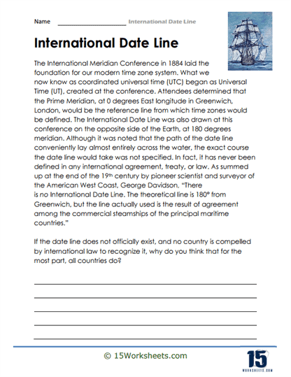
Students learn about the International Meridian Conference of 1884 and how it helped establish modern timekeeping systems. The worksheet explains the connection between the Prime Meridian, UTC, and the International Date Line. It’s a great blend of history and geography.
Longitudinal Degrees
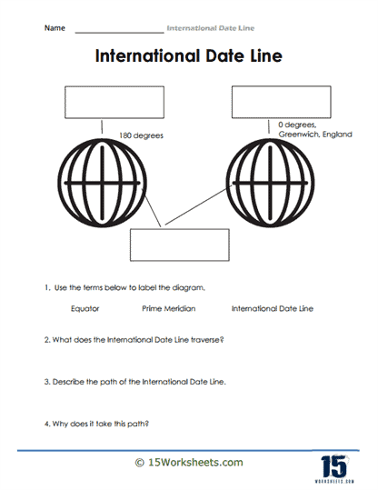
This worksheet helps students identify important geographic markers such as the Equator, Prime Meridian, and International Date Line. The visual layout makes it easier to understand how these lines relate to one another. It’s an excellent geography-building activity.
Time Zones and the IDL
Students explore how time zones and the International Date Line work together to organize time around the globe. The questions encourage them to think about why these systems were created. It’s a helpful introduction to global time management.
IDL Vocabulary
This worksheet strengthens understanding of key terms connected to the International Date Line. Students define important vocabulary and then use the words in context. It’s a great way to build confidence with geography terminology.
Pinpoint Locations
Students define the International Date Line, identify its location, and explain why it matters. They also complete a drawing activity that helps them visualize its place on a world map. The combination of writing and drawing keeps learning engaging.
Foundational Knowledge
This worksheet challenges students with a variety of questions about the International Date Line’s history, purpose, and unique characteristics. Some questions go beyond the basics and encourage deeper exploration. It’s a great activity for curious learners.
I Don’t Want It to End!
Students use their understanding of the International Date Line in a creative way by imagining how they could extend a special day. The activity combines geography with imagination and problem-solving. It’s a fun twist on a complex topic.
True or False
This worksheet tests students’ knowledge of the International Date Line through a series of true-or-false statements. The questions help reinforce key facts while correcting common misconceptions. It’s a simple but effective review activity.
IDL Fill in the Blanks
Students complete sentences using important terms related to the International Date Line. The activity reinforces vocabulary and core concepts while encouraging active recall. It’s a useful way to strengthen understanding through practice.
Global Time Zones
This worksheet explains why the International Date Line is necessary for keeping the world’s calendar organized. Students learn about its connection to global time zones and explain its purpose in their own words. It encourages both comprehension and critical thinking.
What is the International Date Line?
The International Date Line (IDL) is an imaginary line on the Earth’s surface that roughly follows the 180th meridian (180° longitude), located exactly halfway around the planet from the Prime Meridian (0° longitude). The IDL serves as a demarcation point where the date changes by one day as you cross it. It is not a straight line, as it deviates to accommodate political boundaries and territories.
The main purpose of the International Date Line is to facilitate the uniformity of time and date across the globe, as it separates two consecutive calendar days. When you cross the IDL from west to east, you subtract one day, and when you cross it from east to west, you add one day. This system ensures that all time zones around the world are properly synchronized with each other, taking into account the Earth’s rotation.
The concept of the International Date Line was first proposed during the International Meridian Conference held in Washington, D.C. in 1884. The conference aimed to establish a standardized global time system and designated the Prime Meridian as the reference point for calculating longitude and determining time zones. The IDL was then established as the point where the date changes to maintain consistency in the global time system.
It is important to note that the International Date Line is not enforced by international law, but rather by convention and practical necessity. Countries and territories located near the IDL may choose to align their time zones based on their own requirements, sometimes resulting in deviations from the 180° meridian.