Reading a Map Worksheets
All About These 15 Worksheets
These worksheets offer a rich, hands-on way for children to develop essential navigation and spatial skills. From parks and towns to schools, lakesides, and even treasure islands, each worksheet introduces map reading through familiar or imaginative contexts. Students practice interpreting symbols, using legends, following directions, and understanding spatial relationships-all while engaged in visually appealing and themed activities. They make fundamental map skills feel playful rather than technical, helping young learners build confidence with geography.
The variety across these worksheets ensures that children encounter different map types, layouts, and purposes-whether it’s figuring out how to walk through a neighborhood, finding a store on Shop Street, or plotting a route on Main Street. This exposes them to diverse scenarios-urban, rural, adventurous-encouraging adaptability and critical thinking. Moreover, the narrative elements in some worksheets (like Treasure Island or Zoo Navigation) bring an added layer of engagement, blending creativity with logic. Ultimately, these materials help students become more comfortable with maps and more aware of how they shape understanding of our world.
These worksheets matter because reading maps is both a foundational academic skill and a practical life skill. They help students build visual literacy, reasoning, and problem-solving abilities-skills beneficial in subjects like math, science, and history, as well as in everyday tasks like finding your way around school or home. Practicing with these worksheets equips children to see maps not as puzzles but as tools-and even guides-in their world.
Real-world connections shine through activities like Park Explorer, School Map, or Lakeside Directions, making map-reading directly relevant to students’ lives. At the same time, worksheets like Treasure Island and Trail Adventure spark imagination and show how maps can tell stories or guide adventures. Together, this collection fosters both practical understanding and enthusiasm for map-related exploration-so that kids not only learn but also love to read maps.
Have a Look Inside Each Worksheet
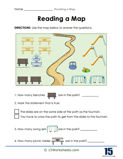
Park Explorer
This worksheet invites students to interpret a park map, identifying landmarks like benches, swings, or picnic tables using the map legend. It nurtures symbol recognition, spatial awareness, and the skill of translating abstract icons into meaningful real-world elements. With its visual and interactive approach, navigating a park becomes both engaging and educational. It’s a playful way to introduce young learners to the concept of reading maps.
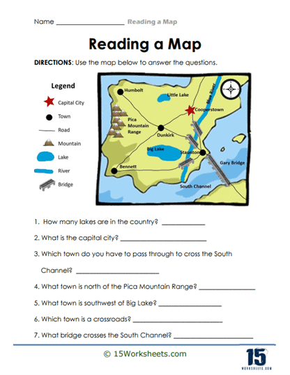
City Navigator
Here, students explore a small city map, using roads and landmarks to navigate from point A to point B. This strengthens their understanding of map orientation, directional terms (like north and south), and how visual cues guide navigation. It turns spatial logic into a mini adventure through urban spaces. Encouraging critical thinking, this worksheet helps kids use maps as real tools.
Town Directions
Students follow or give directions within a town layout, learning to use terms like “turn left” and “cross the street” accurately. This worksheet emphasizes verbal and spatial language skills along with sequential thinking. It feels like being a little urban planner-mapping paths and instructions one step at a time. These abilities help make directions clearer and communication sharper.
Neighborhood Mapping
Young learners create or interpret a map of a neighborhood, pinpointing locations such as homes, parks, or stores. This activity combines creative drawing with logical planning, enhancing both artistic expression and the understanding of geographic relationships. Designing a mini community map taps into their imagination while building map literacy. It’s a hands-on foundation for spatial reasoning and storytelling.
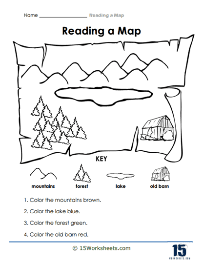
Countryside Colors
With a scenic countryside map colored in various hues, students learn to match areas to their corresponding symbols or descriptive words. This enhances their ability to use map legends and interpret visual information based on color cues. It makes the task of decoding maps feel like uncovering a pretty, patterned landscape. It combines color recognition with map reading in an inviting way.
Trail Adventure
Students follow paths through a trail map, identifying key features like rivers, hills, or rest areas. It boosts their ability to trace paths, estimate distances, and interpret terrain using map symbols. This interactive journey through nature encourages critical thinking and a sense of exploration. It’s map-reading brought to life as an outdoor adventure experience.
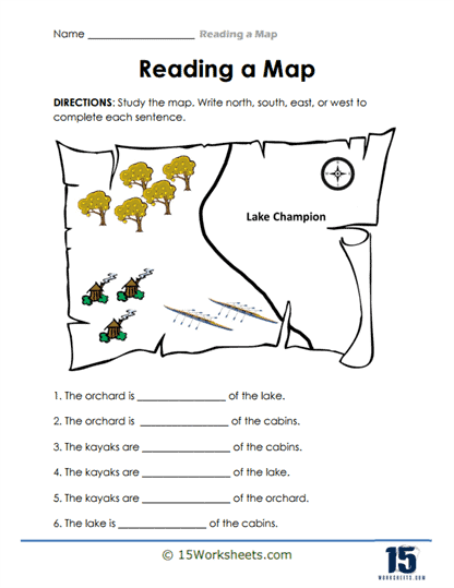
Lakeside Directions
This worksheet has learners navigate a map of a lakeside area, using symbols like docks, boats, and fishing spots to interpret locations. It enhances their navigational skills using real-world-themed content, reinforcing symbol literacy and directional competence. The lakeside setting makes map reading feel like planning a day at the lake. It seamlessly blends geography with storytelling.
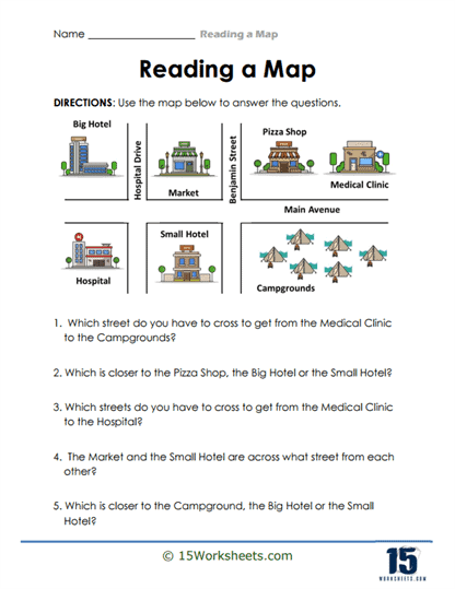
Street Views
Students examine a street map, possibly identifying landmarks or planning routes using visual icons like houses, street names, or traffic lights. This hones their skills of interpreting urban layouts and recognizing patterns in map design. It feels like surveying the local neighborhood from above-turning visualization skills into practical knowledge. It builds an intuitive understanding of how maps represent streetscapes.
Zoo Navigation
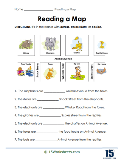
Learners use a zoo map, complete with animal enclosures and pathways, to answer questions like “Which way to the lion?” or “Where is the reptile house?” This worksheet sharpens their map-reading skills with fun-to-follow directions and playful context. It encourages logical sequencing while exploring a zoo environment. It’s educational while feeling like a day out with maps.
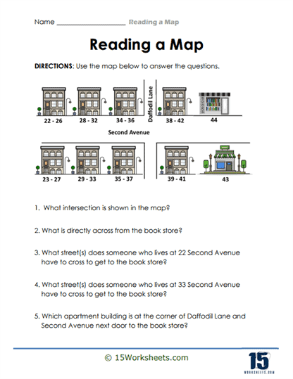
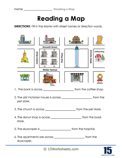
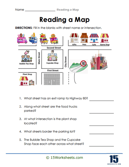
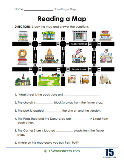
Shop Street
Here, students navigate a commercial street map filled with various stores, learning to locate specific shops using map keys and symbols. It supports symbol interpretation, logical navigation, and contextual awareness in everyday settings. A stroll down Shop Street becomes a learning journey as they use clues to find where the baker or the toy store is located. It turns directions into a community scavenger hunt.
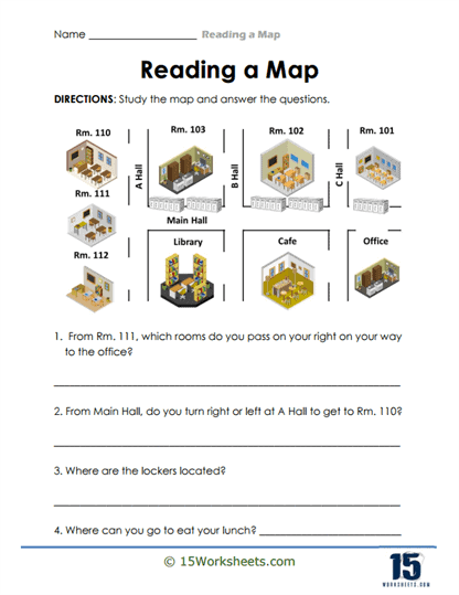
School Map
This worksheet features a school layout where students identify rooms or landmarks like the cafeteria or playground using the map. It builds familiarity with common symbols, enhances spatial orientation, and supports language skills as kids describe locations. It offers a familiar backdrop that connects learning with their daily environment. It helps students learn navigation through spaces they know well.
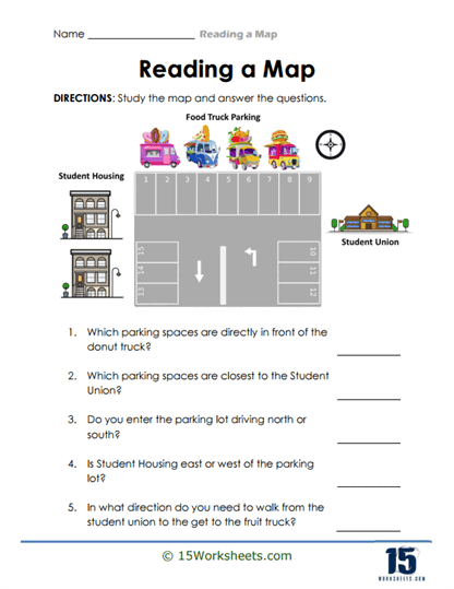
Parking Lot Puzzle
Learners interpret a parking lot layout-identifying spaces, exits, and pathways. This sharpens their ability to decode structured maps and use directional thinking within a practical context. Turning parking layouts into puzzles makes the learning feel light-hearted yet purposeful. It’s a creative way to combine logic with everyday maps.
Town Block Hunt
Students explore a town grid map, locating certain blocks based on clues or directions-like “find the third block east of the library.” This worksheet reinforces understanding of coordinates and relational directions. It’s like playing detective on a town map: finding places with clues and logic. It builds both spatial reasoning and attention to detail.
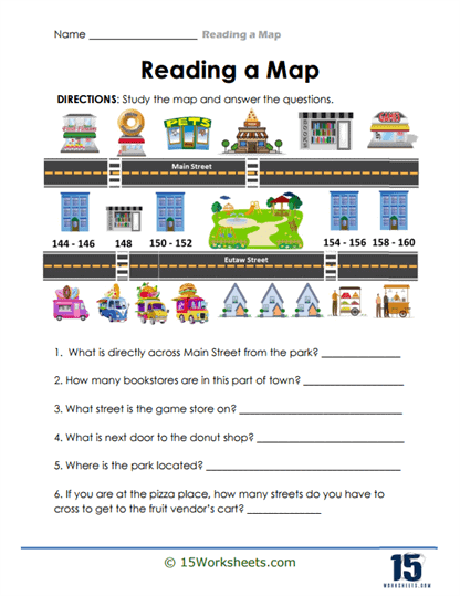
Main Street Stroll
With a map of Main Street, students either navigate a route or identify key locations along the street. This enhances their understanding of sequential navigation, landmarks, and visual mapping. Walking Main Street on paper becomes an opportunity for storytelling and route tracing. It bridges map reading with real-world community awareness.
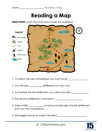
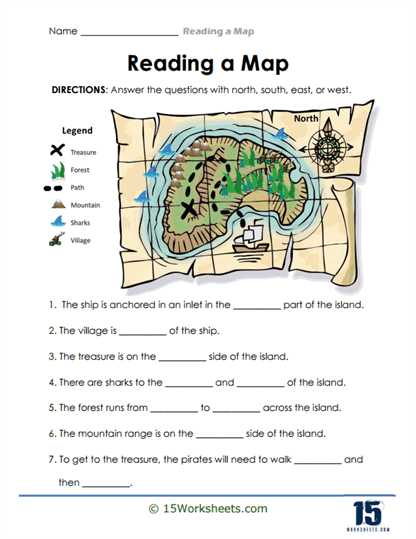
Treasure Island
This imaginative worksheet casts students as treasure hunters using a map marked with an “X” and various landmarks. They interpret symbols and directions to find the treasure, engaging both logic and creativity. It feels like a miniature adventure requiring careful observation and planning. Perfectly merges fun with the core skills of map use.